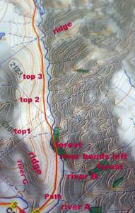
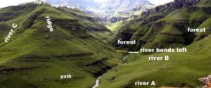
Today we look at some more fundamental skills of navigation in the wilderness. Using the examples below we can look at three necessary skills. We will also identify some very common mistakes.
Firstly, if you are finding your way along unfamiliar terrain or in bad visibility, study the map before hiking along any given section. Then try to visualise what the terrain will actually look like before you get there. This includes trying to understand what you will actually see from ground level. So in the picture below, look at some of the features identified on the map and try to see them on the landscape.
Secondly find some “tick points”. Tick points are rather like walking down a street, trying to find, say, a certain shop that sells clothes. To get there you have to pass the Post Office on the left, then walk about 100 metres and turn right, then pass the supermarket on the right and then you get to the clothes shop. You do it the same way in the mountains. So, if hiking up the path in the example, you would say, “I’m on the path about 100 metres above the river, which is on my right. I walk about 500 metres till where the river will bend left. I cross the river, then cross it again and pass the forest on the right” and so on…
Thirdly, it is important to fold the map to the area of interest, then hike with it in your hand, referring to it as you go. A common mistake is to put the map away, hike for a long distance, then sit and try to work out where you are. This is not the way to do navigation!
By using this technique, it can be said that you never get lost, because you always know here you are.
Happy hiking and for more information on courses contact: gavin@peakhigh.co.za or check out www.peakhigh.co.za

