Using rivers as aids to navigation is a very useful technique.
It is all about looking at the finer details and remembering that map makers tend to be very accurate when showing natural features. It takes a practiced eye to see certain very small, but useful features. Some of this is also simple logic, yet very important. These skills can be done in good visibility while high above a river, or even right at the river’s edge, when moving in mist or at night. Often tiny non-perennial streams hold the key to it all. It enables one to have absolute pin point accuracy at all times.
The maps used in these examples are 1:50000 so 2cm = 1 km or 2mm = 100m.
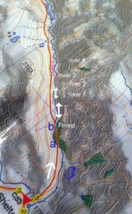
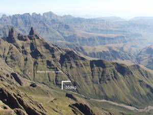
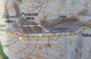
Look at the map of the Pholela valley in the southern Drakensberg. The white arrow shows the direction of travel; the blue shows the direction of river flow. That brings us to point number 1. Know which way the water will be flowing by looking at the contours – especially in bad visibility. This means that where the path crossed the river at “point a” the water will run left to right. Then 500m further on it will run right to left at “point b”. It’s completely logical, but worth remembering when negotiating unknown areas in zero visibility. Then after this crossing, a hiker can see the edge of the trees. They then note that it is approx 7mm or 350m from there to stream 1, followed by 5mm or 250m to stream 2 and so on. These distances can be measured on the side of a compass base-plate. Note also the S-bends in the main river. On this scale of map the radius of a curve in a river must be at least 200m, before it shows on a map. The kinks, turns and meandering shapes are a huge help to see where you are located on a map. The other 2 images show another important clue to a hiker’s position. The angles at which small side streams meet a river, actually show clearly on the ground. In these examples a person walking up-stream would pass the first stream and note it enters at 35 degrees, then a little further up, there is a stream running off left at 110 degrees and note that on the opposite side of the valley there are 2 streams which end 400m up the slope. A little further up they would note the fork in the stream about 300m up the slope.
Safe hiking and for more information on MDT certified courses, contact gavin@peakhigh.co.za


